Typically, an aquifer receives most of its water inflow from areas known as recharge areas. These are the areas where the aquifer is exposed at the ground surface and the water moves more freely downward through the aquifer materials. This contrasts with locations where aquifers underlie layers of finer sediment (such as clay). The finer sediments act as barriers to the downward movement of water into the aquifer. In these areas the aquifer is "confined."
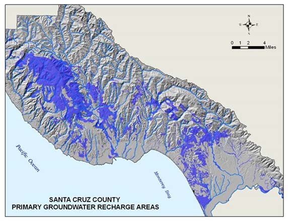
The County of Santa Cruz designates the areas where an aquifer is exposed at the ground surface and allows water to move downward into the aquifer as Primary Groundwater Recharge (PGR) zones. As such, these areas are given special consideration and protection from development. This protection allows the aquifers to maintain an adequate quantity and quality of groundwater recharge. A map of County designated primary groundwater recharge areas is presented below.
Parcels outside the urban services line and within mapped PGR cannot be subdivided smaller than 10 acres. The rationale for this is to 1) minimize the blockage of the aquifer recharge areas inherent to development and 2) reduce the amount of impacts to the recharge water quality from septic systems and other site activities. An indirect benefit of the lower development density is that it reduces the amount of potential groundwater extraction from those areas.